
i-Boating:New Zealand Marine Charts & Fishing Maps cho Android
- REQUIRES ANDROID | Danh mục: Travel
Xếp hạng
từ 0 Bình chọn |
$ 329.000đ
- REQUIRES ANDROID | Danh mục: Travel
 |
 |
 |
 |
 |
Tệp APK (Bộ gói Android) là tệp thô của ứng dụng Android. Tìm hiểu cách cài đặt i-boating-new-zealand-marine-charts-fishing-maps.apk tệp trên điện thoại của bạn trong 4 bước đơn giản:
Đúng. Chúng tôi cung cấp một số bản sao tải xuống Apk an toàn nhất để nhận i-Boating:New Zealand Marine Charts & Fishing Maps apk.
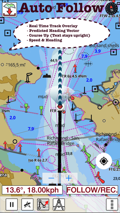
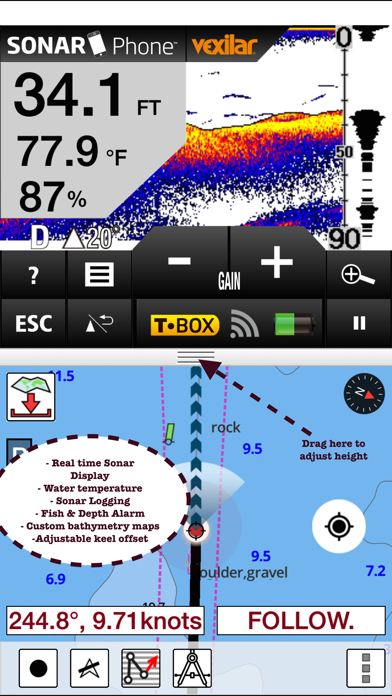
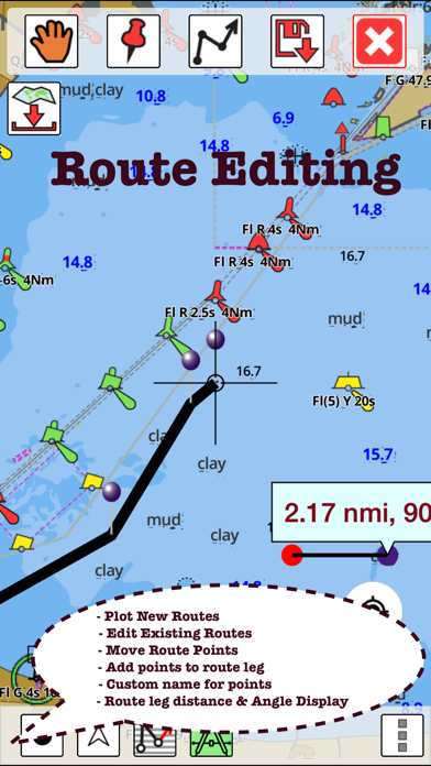
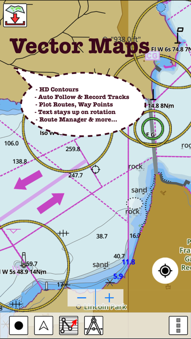
GPS Marine Charts App offers access to charts covering New Zealand waters (derived from LINZ(Land Information New Zealand (LINZ) - Toitū te whenua)data). Only marine GPS app to have route assistance with Voice Prompts for marine navigation. It has route manager to create new boating routes or import existing GPX/KML routes. It supports Nautical Charts course up orientation. Please visit http://gpsnauticalcharts.com/main/new-zealand/all-all-new-zealand-charts-nautical-charts-folio.html for complete list. If you don't find the chart for New Zealand , please contact us at support at gpsnauticalcharts.com. * Voice Prompts for marine navigation (requires GPS ) -prompts when approaching a boating route marker -Continous distance and ETA updates -Alerts when sailing/boating off route -Alerts when boating in wrong direction *Route Editing/Creation -Create routes from scratch -Edit existing GPX/KML routes. -Add custom description to any route point. -Drop markers along route. * Offline charts derived from KMS/GST data. -Visually draw area to download -Textual search -Catalog -Charts reprojected for WGS84 datum *Seamless chart quilting of marine charts *Distance Bearing tool *Create custom way points - Using GPS -Select point on map -Manually enter latitude & longitude coordinates *POI layer for marine charts - Overlay POIs - POI list derived from the equivalent ENC & contains all categories including Buoy, Light, Harbour facility, Obstr. *Search POIs/Way points *Pan/Zoom/My Location * Record Marine GPS tracks * View tracks overlay * Live track animation * Track analytics/stats * Export GPX tracks. -Export to SDCard -Share GPX trakcs with friends. * Auto Follow Mode (Course up) -Continuously updates boat's location on chart - Adjustable update frequency Sample Nautical Charts Waikato River Horomatangi Reef Lake Taupo Tapuaeharuru Bay Evans Bay Point Howard & Seaview Wharves Lambton Napier Westport Horseshoe Bay-Ulva Paterson Inlet/Whaka a Te Wera Onehunga Wellington Kaikoura Pukapuka Penrhyn Manihiki Anchorage Penrhyn Taruia Passage-Gudgeon Bay Nassau Manihiki Suwarrow Opua Wharf Kerikeri Inlet & Te Puna Inlet Cape Reinga-Manukau Cook Strait Cape Adare-Cape Daniell Nelson Stewart/Rakiura-Macquarie Port Taranaki Nuku'alofa Motiti-Pehitari Point Ohiwa Whakatane Chatham-Ile Rapa Bluff Cape Egmont-Rangitikei Foveaux Strait Goat-Waiwera Tauranga Waitangi Bay Port Hutt Stephens Passage Te Aumiti (French Pass) Port Gore Forsyth & Guards Bays Napier Picton Wharves Tory Channel Entrance Picton Dusky Sound Great Barrier (Aotea) Poor Knights, High Peak Rocks & Sugar Loaf Rock Niuafo'ou Frankton Arm-Queenstown Bay Queenstown Bay Lake Wakatipu Queenstown Bay-Picnic Point Calliope Wharves Apia Marlborough Sounds Auckland Port Golden Bay (Tarakohe) Abel Tasman Port Underwood Ingles Bay Norfolk-Cape Egmont Marsden Point Kawhia Rauoterangi Channel & Kapiti Cape Royds-Pram Point Tamaki Port Pegasus/Pikihatiti Port Adventure & Lords Tutaekawetoweto Okurei Point Neiafu Deep Cove LPG Terminal Tasman Sea New Zealand-S.E. Australia Alofi Landing Alofi Anchorage Niue Chatham Bream Tail-Kawau(Aotea) Macauley Raoul Curtis & Cheeseman Tonga Cape Karikari-Cape Brett Otago Riverton/Aparima Balleny Seamount Balleny Cavalli Passage Samoa Lyttelton/Whakaraupo Port of Lyttelton Nuku'alofa McMurdo Station & Scott Base Cradock Channel & Mokohinau Whanganui River Castlecliff Wharves Samoa Timaru Coral & Solomon Seas & adjacent seas Kaipara Wairoa Mangonui Whangaruru Parengarenga Breaksea Sound & Dusky Sound Samoa-Tonga including Niue Niuatoputapu Porirua Apolima Strait Matautu Bay Katiki Point-Nugget Point Whangarei Great Barrier Smith-South Cape North Cape Doubtless Whangaroa Anchorage Antipodes Perseverance Campbell/Motu Ihupuku Bounty Castle Point-Cape Palliser Milford Sound/Piopiotahi PLEASE NOTE: Continued use of GPS running in the background can dramatically decrease battery life.
Apk Mirror 1: : Tải về APK
|

|

|

|

|

|

|

|

|
|

|

|

|

|

|
|

|

|

|

|

|

|

|
|

|

|
|

|
|