
Singapore MRT Map Route para Android
- REQUIRES ANDROID | Categoria: Navigation
Classificação 4.33333
De 3 Votos |
$ Gratuito
- REQUIRES ANDROID | Categoria: Navigation
 |
 |
 |
 |
 |
Arquivos APK (Android Package Kit) são os arquivos brutos de um aplicativo Para Android. Saiba como instalar singapore-mrt-map-route.apk arquivo em seu telefone em 4 passos simples:
Sim. Fornecemos alguns dos espelhos de download do Apk mais seguros para obter o apk Singapore MRT Map Route.
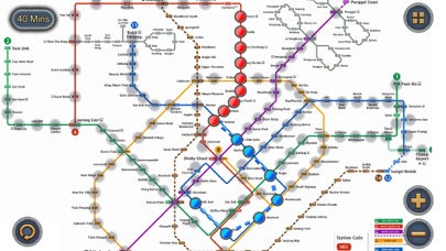
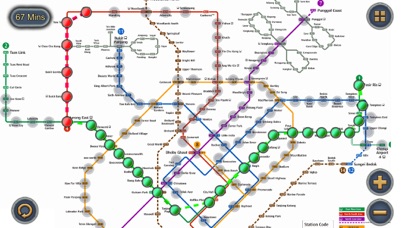
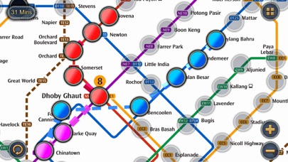
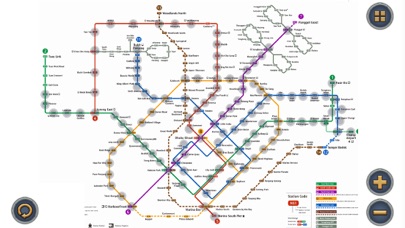
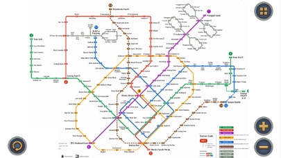
Singapore MRT Map Route de Wan Peng tem uma classificação de 4 estrelas no Baixarapk e foi avaliado por mais de 3 pessoas. A versão mais recente do Singapore MRT Map Route é a versão 2.4.5 e foi atualizada pela última vez 1 year ago. Updated Thomson-East Coast Line (TE1 Woodlands North to Orchard) to the subway system Singapore's MRT system is extending. By 2030, the MRT system will be more complex than you could image. It's good for all residents on our lovely island. But also will be a problem because we don't know how to travel the fastest when transfering stations. Singapore MRT Map Route is designed to allows user to get the best route within a second. It will help you save a lot of time over years. - View lastest Singapore MRT map - Display the best route between two stations - Automatically calculate estimated travel time - Require no internet connection. Updated to latest MRT system: Downtown Line(Blue) Bukit Panjang, Cashew, Hillview, Beauty World, King Albert Park, Sixth Avenue, Tan Kah Kee, Botanic Gardens, Stevens, Newton, Little India, Rochor, Bugis, Promenade, Bayfront, Downtown, Telok Ayer, Chinatown Circle Line(Yellow) Dhoby Ghaut, Bras Basah, Esplanade, Promenade, Nicoll Highway[C], Stadium, Mountbatten, Dakota, Paya Lebar, MacPherson, Tai Seng, Bartley, Serangoon, Lorong Chuan, Bishan, Marymount, Caldecott, Botanic Gardens, Farrer Road, Holland Village. Buona Vista, one-north, Kent Ridge, Haw Par Villa, Pasir Panjang, Labrador Park, Telok Blangah, HarbourFront East West Line (Green) Pasir Ris ,Tampines , Simei , Tanah Merah , Bedok , Kembangan , Eunos , Paya Lebar , Aljunied , Kallang , Lavender , Bugis , City Hall , Raffles Place , Tanjong Pagar , Outram Park , Tiong Bahru , Redhill , Queenstown , Commonwealth , Buona Vista , Dover ,Clementi , Jurong East , Chinese Garden , Lakeside , Boon Lay , Pioneer , Joo Koon, Expo, Changi Airport North South Line (Red) Jurong East, Bukit Batok, Bukit Gombak, Choa Chu Kang, Yew Tee, Kranji, Marsiling, Woodlands, Admiralty, Sembawang, Canberra, Yishun, Khatib, Yio Chu Kang, Ang Mo Kio, Bishan, Braddell, Toa Payoh, Novena, Newton, Orchard, Somerset, Dhoby Ghaut, City Hall, Raffles Place, Marina Bay, Marina South Pier North East Line (Purple) HarbourFront, Outram Park, Chinatown, Clarke Quay, Dhoby Ghaut, Little India, Farrer Park, Boon Keng, Potong Pasir, Woodleigh, Serangoon, Kovan, Hougang, Buangkok, Sengkang, Punggol. Baixe o aplicativo em 87.91 MB agora. Se você gostou de Singapore MRT Map Route, você vai gostar de Navigation apps como hitta.se; Speedometer; Compass; Tide Graph; iStellar;
Espelho 1: : Baixar APK

|

|

|
|

|

|

|
|

|

|

|

|

|

|

|

|

|

|

|

|

|

|

|

|
|